

Tailored to your needs: the new avalanche bulletin for your region 
What did the avalanche forecasters do over the summer? They worked with our development team to revise the avalanche bulletin. The aim was to make it simpler while providing more detailed information. How? By ensuring that “MyBulletin”, as the project is called, displays exactly what matters in the selected area. Nothing more, nothing less.
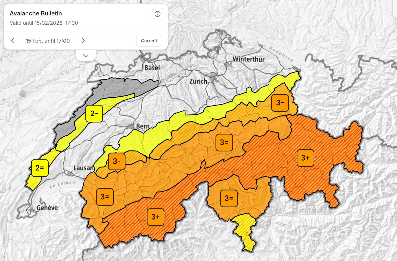
Image 1 of 3
The danger map now also shows the intermediate danger levels. Areas with the same characteristics are outlined by a thicker black line.
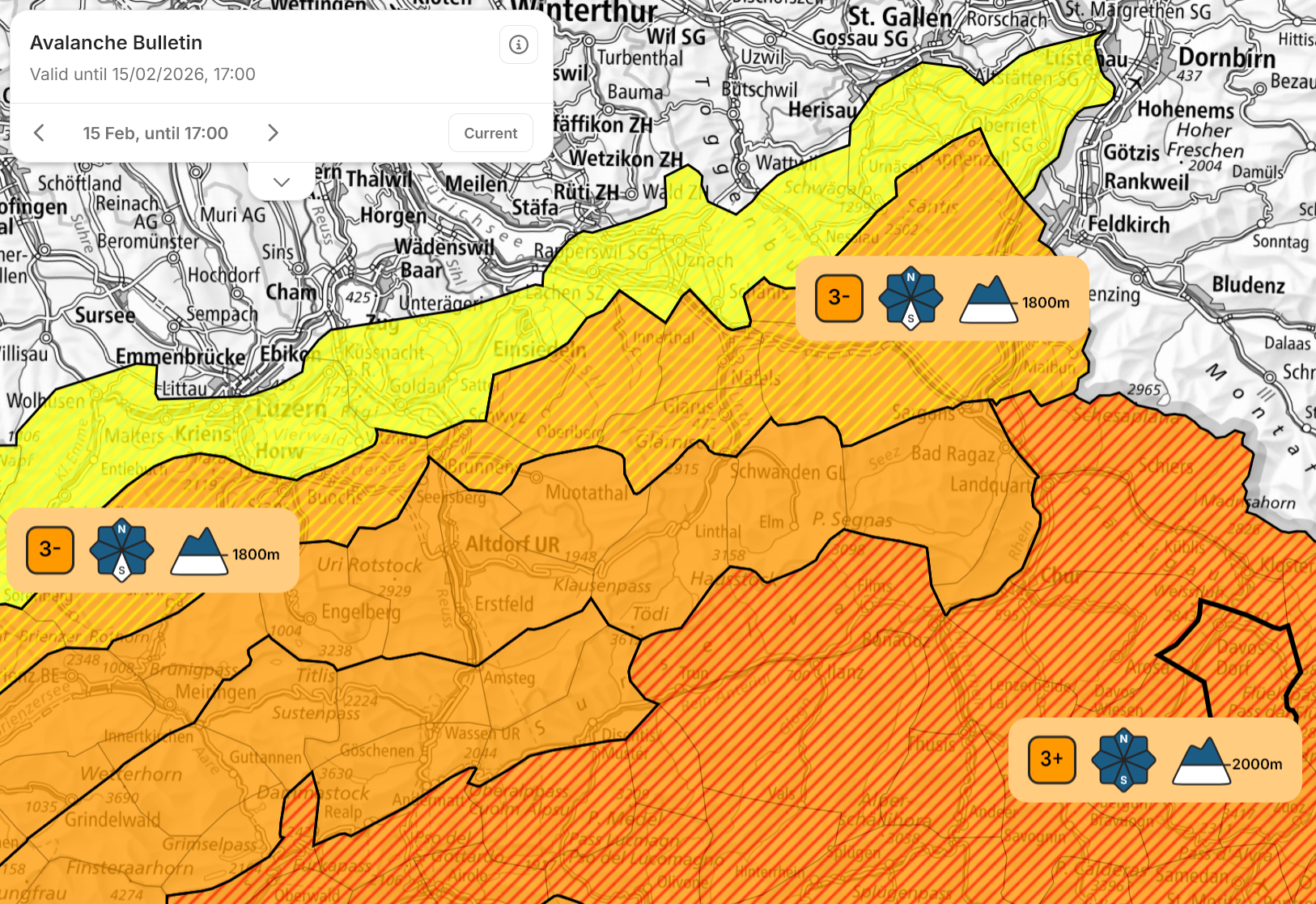
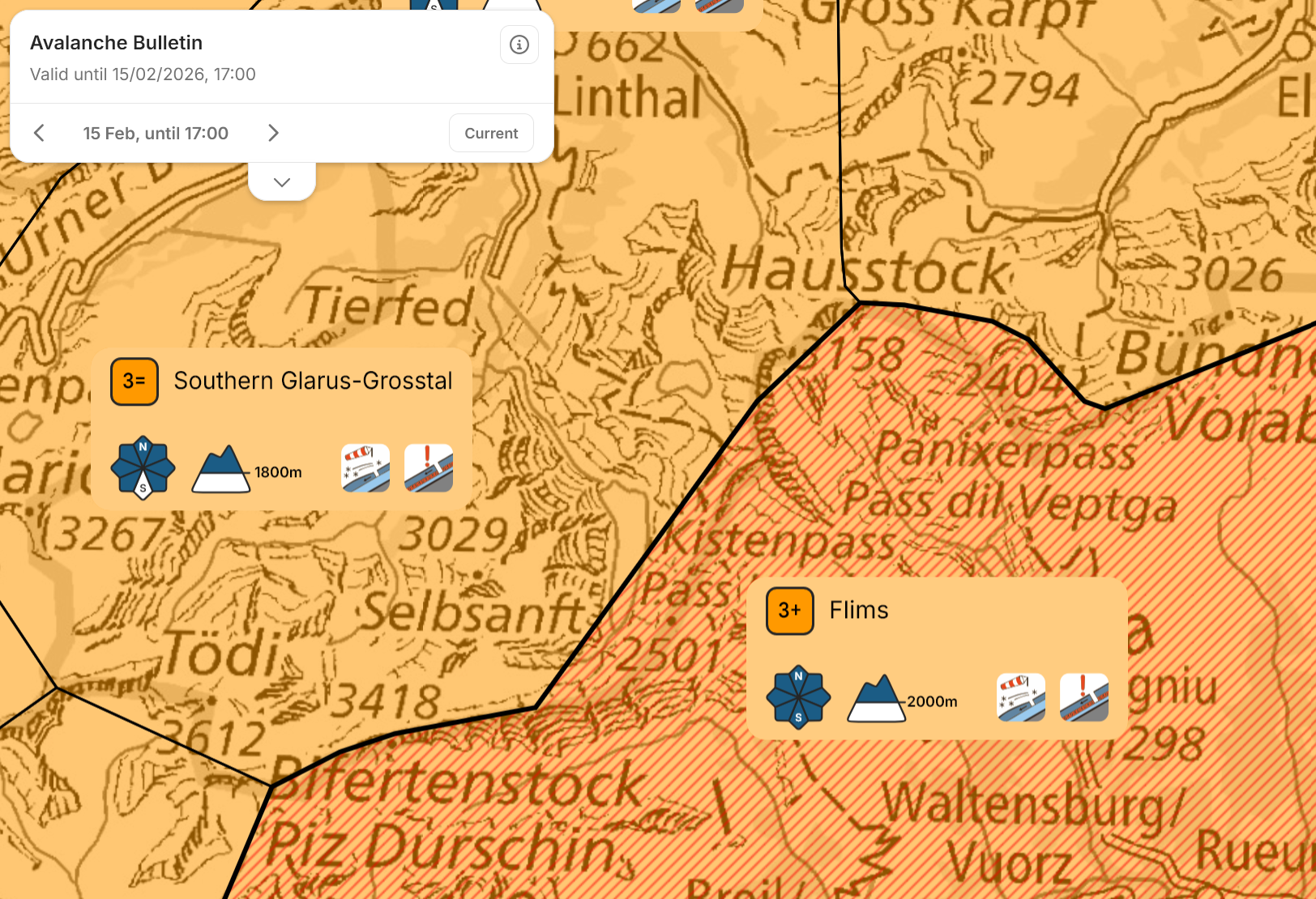
You can already see all the updates described here on whiterisk.ch – the update for the WhiteRisk app will be launched in a few days.
Gone are the days of having to search through long texts for the information you need. What does that mean in practice? An overview map with more detail, a separate description of the snowpack, weather data for each warning region, an outlook for the day after tomorrow and a calendar for accessing previous bulletins.
Overview map 
If you do not live in the mountains, you may be wondering where to go for your next ski tour. The overview map can provide an initial answer. That is why it now also shows the intermediate danger levels (see the images above). Zooming in further reveals the critical altitudes and aspects, followed by the avalanche problems.
Location-specific information 
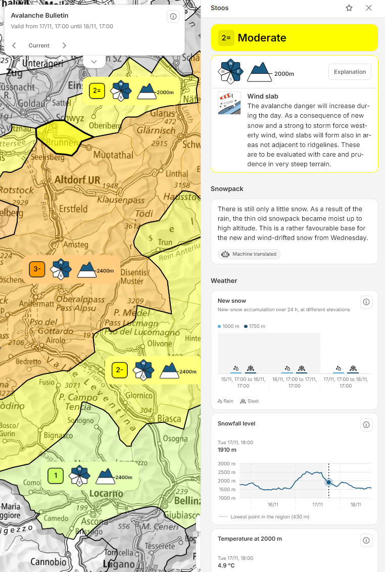
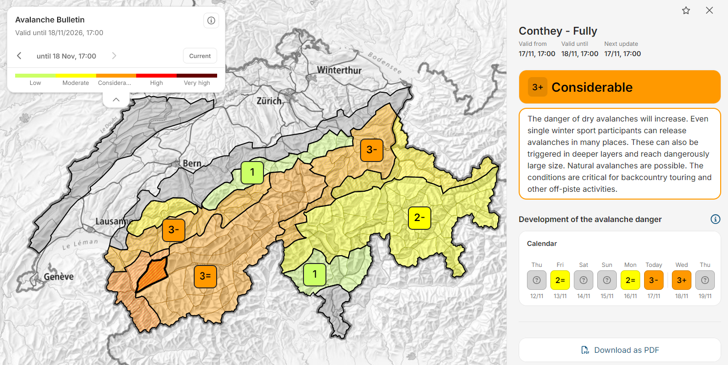
Once you have chosen an area and clicked on the map, you will see precisely the information relevant to that location (Fig. 1). So, if you are interested in the St. Moritz region, you will receive the information that applies there. You will no longer have to pick it out from among descriptions of the snowpack in Valais and weather developments in the Jura. Regions can now also be saved as favourites and accessed directly.
Local displays are easy to read and are widely used in weather apps. In the avalanche bulletin, “local” refers to one of Switzerland’s 149 warning regions. These are the smallest areas for which the bulletin assesses avalanche danger. Providing a danger assessment for an exact location would make little sense and could even be dangerous: for example, the danger displayed at the bottom station in Verbier could be quite different from the conditions that actually apply higher up on Mont Fort.
Bulletins tailored to individual warning regions are new to avalanche forecasting. Major changes were needed to enable all content to be assigned geographically. Descriptions such as “on the northern Alpine ridge east of the Reuss, excluding the Alpstein, and also in the Prättigau” have had their day – and we will not miss them.
Snowpack 
The snowpack determines avalanche danger. In future, it will be described in a separate section immediately after the danger description. For you as users, this means more information and greater precision. For us as avalanche forecasters, it means an additional layer in our editor (Fig. 2). Preparing this description now takes more time than before. Given how important this parameter is, we believe the extra effort is justified.
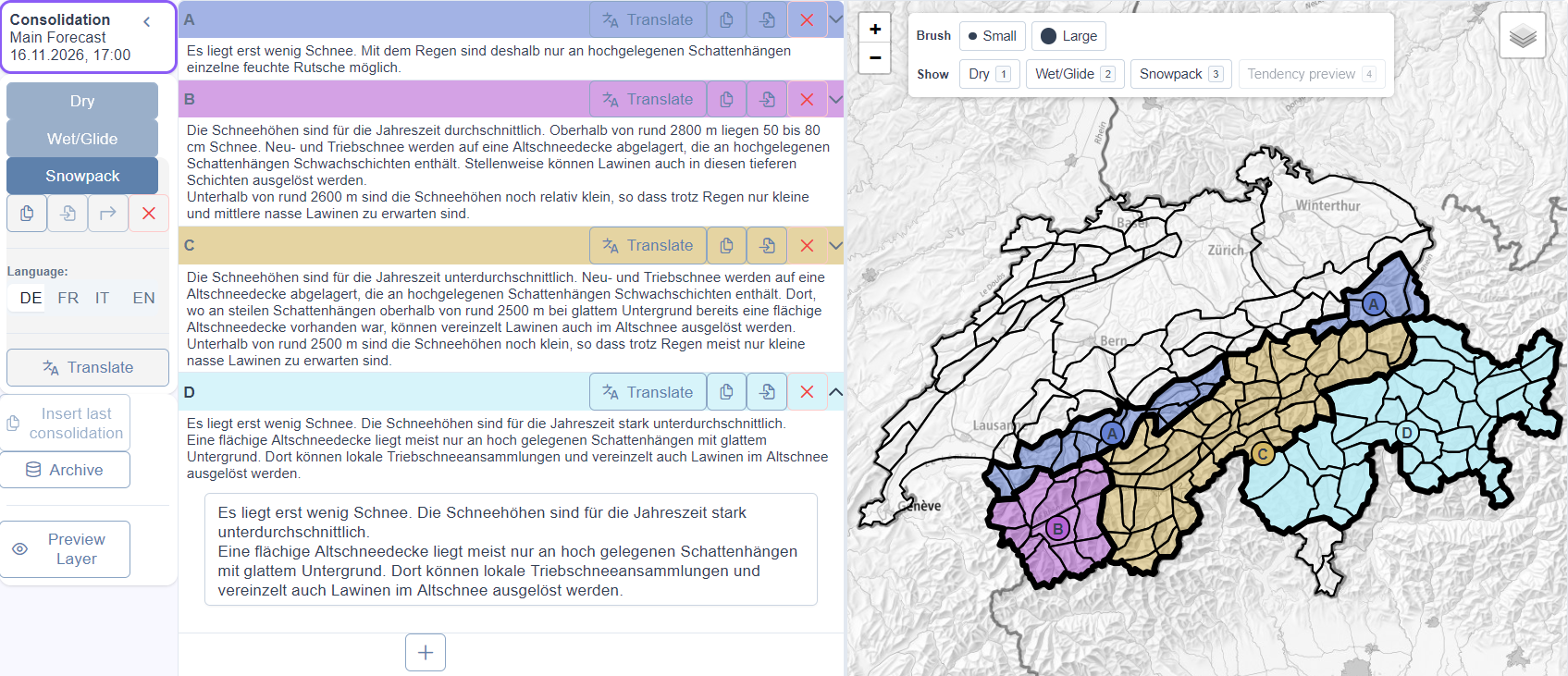
The texts are written in German. To ensure an efficient workflow, translations into French, Italian and English must be generated automatically. The danger descriptions are translated using the sentence catalogue, a collection of text modules available in all languages. Expanding this catalogue would also make it possible to describe the snowpack. However, both extending and using the sentence catalogue are very labour-intensive. A more efficient approach is to write free-form texts and translate them using commercial tools such as DeepL, GPT or Claude – but this raises the question of quality. Quality was assessed in an extensive blind test. The aim was to ensure that the translations were at least as good as those in previous avalanche bulletins. The benchmark was therefore the snowpack descriptions from recent years, as published on WhiteRisk in the different languages.
- First, the German snowpack descriptions were translated into the various target languages using different tools. A glossary was provided to ensure correct translations of technical terms.
- Next, avalanche experts proficient in the relevant languages evaluated the different translations (both the newly generated versions and those previously published on WhiteRisk) against defined criteria. Of course, they did not know how any particular translation had been produced.
The evaluation showed that the translations produced by GPT-5.5 Pro were rated more highly than the previous translations in all languages. We will use these translations in future and hope that this level of quality is maintained in day-to-day operations. A second, alternative translation tool is available as a backup.
Weather 
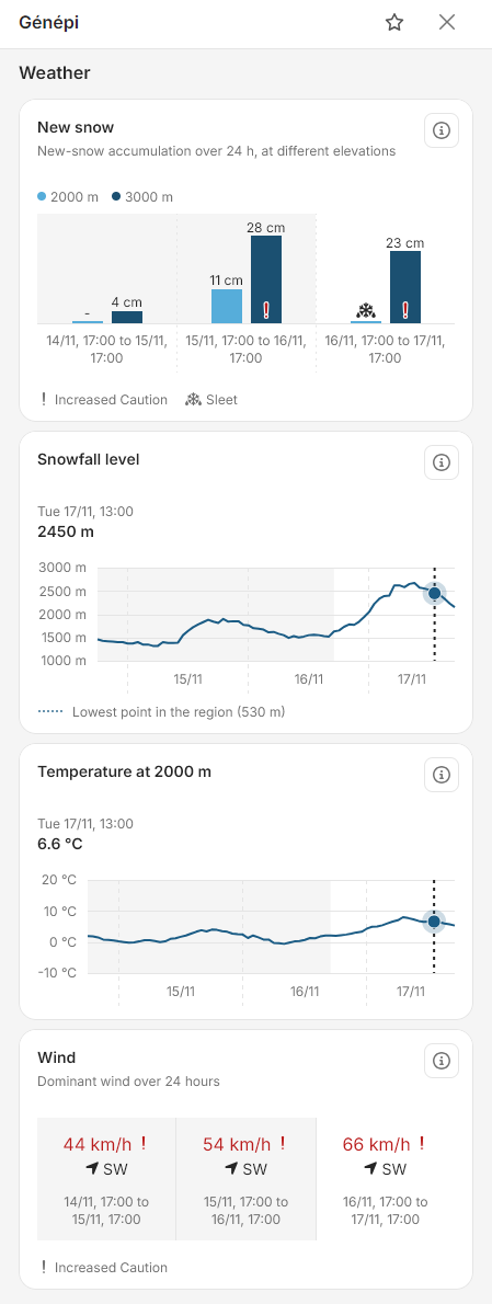
No, developing our own weather app is not part of the avalanche forecasting service’s remit. There are already plenty of them. Nevertheless, the weather is important because it has a very direct impact on avalanche danger. And despite the many apps available, it is often surprisingly difficult to find the relevant information: weather reports are frequently geared towards populated areas. For winter sports, however, we are interested in the mountains – and not just the forecast, but also how the weather has developed over the past few days.
In future, the most important weather parameters (amount of fresh snow, snowfall level, temperature and wind) will be displayed for every warning region (Fig. 3). The information covers the previous two days and the forecast day (i.e. the day for which the bulletin is valid). These are calculated values from MeteoSwiss and the OSHD (the SLF’s operational snow-hydrological service), averaged across the respective warning region. Unlike weather apps, the weather data will deliberately be updated only when the bulletin is published. The display will therefore always show the information available at the time of publication, which formed the basis for the avalanche danger assessment. If you find while out in the mountains that the local weather has developed differently, you should adjust the avalanche danger forecast accordingly.
In future, the most important weather parameters (amount of fresh snow, snowfall level, temperature and wind) will be displayed for every warning region (Fig. 3). The information covers the previous two days and the forecast day (i.e. the day for which the bulletin is valid). These are calculated values from MeteoSwiss and the OSHD (the SLF’s operational snow-hydrological service), averaged across the respective warning region. Unlike weather apps, the weather data will deliberately be updated only when the bulletin is published. The display will therefore always show the information available at the time of publication, which formed the basis for the avalanche danger assessment. If you find while out in the mountains that the local weather has developed differently, you should adjust the avalanche danger forecast accordingly.
Outlook – a better indication of the trend 
In future, the 5 pm edition will include not only a bulletin for the forecast day but also an “outlook”. This is an additional bulletin for forecast day 2 and replaces the rather general text previously produced for Switzerland as a whole (Fig. 4).
The outlook follows the same structure as the forecast for day 1 but is shorter. It provides the essentials for each warning region: the danger level, intermediate danger level and a description of the danger.
For high danger levels and special avalanche situations, the avalanche forecasters write the danger descriptions in the outlook using the sentence catalogue, just as they do for forecast day 1. This additional effort is not feasible for every area. Under “normal” avalanche conditions, predefined texts are therefore used, selected automatically on the basis of the assessments in the bulletin.
Goodbye, complete avalanche bulletin – hello, calendar 
With the updated avalanche bulletin, we have to say goodbye to a few familiar features:
- The individual warning regions will no longer be grouped into “danger areas”. With the snowpack description as a third layer, there would be so many such areas that grouping them would make the presentation confusing. Moreover, displaying local weather data and changes in avalanche danger over the preceding days for each warning region is only possible without this grouping.
- Without this grouping, there will also no longer be a “complete avalanche bulletin” available to download as a PDF, as there was previously. However, a PDF will still be available for each warning region.
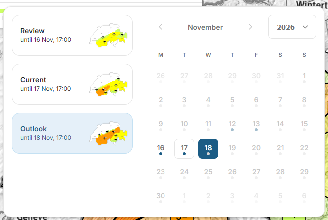
The calendar in WhiteRisk now also lets you view past bulletins (Fig. 5). It displays three clickable bulletins directly beneath one another: the previous bulletin, the current bulletin and the outlook. Even the small maps show whether avalanche danger is increasing or decreasing. Clicking on one of the maps (buttons) or on a date opens the corresponding bulletin on the WhiteRisk map, exactly as it was published at the time. You can then select an area and, if needed, download a printable PDF version. This can also be posted in ski areas.
We wish you safe tours with the new avalanche bulletin – and a wonderful winter with plenty of snow!
Danger trend
Bulletins of this time period
