The WSL Institute for Snow and Avalanche Research SLF uses the avalanche bulletin and various supporting products to inform the public about the current snow and avalanche situation in the Swiss Alps and in the Jura. The content of the avalanche bulletin is designed as an informed warning. It is published one to two times a day in winter and primarily contains a forecast of the avalanche danger in the Swiss Alps, Liechtenstein and, when there is sufficient snow cover, the Jura as well.
Additional information about the weather's effects in terms of avalanches and the condition of the snowpack gives users a clearer picture of the current situation and provides a basis for making their own assessment, as the information provided the avalanche bulletin cannot take the place of their own local on-site assessment. The information contained in the bulletin is too general for this because of the limited data it is based on.
Target audience
The avalanche bulletin is aimed at all those who are exposed to potential avalanche danger in the mountains in winter, whether in a professional or recreational capacity, and those who are responsible for the safety of others. This includes members of the following groups:
- Avalanche services and committees of the communal authorities and civil engineering offices, as well as the safety services of the mountain railway/cableway operators
- The police and rescue services and the armed forces
- Mountain guides, snow sports instructors and backcountry tour guides
- Residents of mountain villages
- Winter sports enthusiasts away from secured ski runs, such as freeriders, backcountry skiers, snowshoe hikers, mountaineers and ice climbers
When the snow and avalanche situation is relatively favourable, the avalanche bulletin will mainly contain information for winter sports enthusiasts. From danger level 3 (considerable) upwards, information for the avalanche warning services is issued more frequently. At the very high avalanche danger level (level 5), when snow sports are hardly possible anyway, the avalanche bulletin will mainly contain information for the avalanche warning services.
Structure of the avalanche bulletin
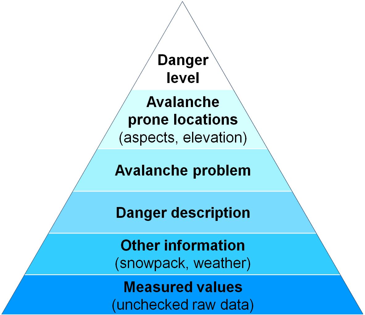
In high season the structure of the avalanche bulletin is based on the 'information pyramid', i.e. the most important comes first (danger level), followed by details of the locations where the danger level applies and then the avalanche problem, the danger description and information about the snowpack and the weather. Finally, measured data can also be displayed. The use of standardized terminology aids both understanding and implementation.
Individual parts of the avalanche bulletin
The avalanche bulletin consists of a zoomable hazard map, including a hazard description and a section headed "Snowpack and weather". A description of this content is given below. In the off-peak periods and during large snowfalls in summer, the avalanche warning service usually has less information available than in winter. Then the avalanche bulletin is less detailed, and areas with danger level 1 (low) are not always described.
Avalanche danger
The avalanche bulletin's most important component is its avalanche danger forecast. This comprises the following aspects:
Danger level and avalanche prone locations
The danger of dry and wet avalanches is assessed separately. The danger level indicated is based on the five-point European avalanche danger scale. When there is a moderate or higher danger of dry avalanches (starting at level 2), the points on the scale are also subdivided (-, =, +). In most cases, the endangered aspects and altitude zones are pinpointed as well. Warning regions are grouped together whenever an identical danger level (in identical aspects and altitude zones) applies, provided that the avalanche problems are also the same and the dangers can be described appropriately for all the affected regions. The danger description may contain additional information concerning terrain types that are particularly affected.
On the danger map, the maximum expected danger level is shown for each warning region (maximum of dry and wet danger). If the danger level is likely to change during the day, the danger level is normally based on the situation in the morning. In typical springtime conditions, two maps show both the more favourable morning situation and the more unfavourable situation in the afternoon (double map).
Avalanche problems
For each warning region, the avalanche danger is classified as falling under one or more of the five 'typical avalanche problems'.
“Dry-snow avalanches” summarises the following avalanche problems:
- New snow (considerable snowfall in recent days)
- Wind slabs (snow transported by the wind)
- Old snow (weak layer(s) prone to triggering within the old snowpack)
“Wet-snow avalanches” (referred to as “wet avalanches”, “gliding avalanches” or “wet and gliding avalanches” depending on the situation) summarises the following avalanche problems:
If there is no conspicuous avalanche problem (often when a low avalanche danger (level 1) applies), the situation is described with the text "no distinct avalanche problem".
Danger description
There is a specific danger description for each danger region marked on the map, with the danger of dry and wet avalanches being described separately. The danger description reflects the conditions in the altitude zones and aspects where the danger level applies. Outside these altitude zones and in other aspects it can be assumed that a fundamentally similar, but more favourable, avalanche situation exists. In other words, the avalanche prone locations are likely to be found less frequently in these places. Among other factors, the danger description can contain information concerning the likelihood of release and the size of the anticipated avalanches or relating to the snowpack structure. If necessary, remarks or recommendations for individual groups of users are also provided.
Snowpack and weather 
This part of the avalanche bulletin is only updated in the evening and is made up of the following parts:
Snowpack
The snowpack is the principal determining factor in the formation of avalanches. A general description is given, usually covering both the layering of the snow and the stability. While snow layering is determined by the stratification of the snowpack and the structural properties of its individual layers (grain shape and size, hardness). The snow layering is crucial to snowpack stability. This section also describes the observed avalanche activity if applicable.
Weather
The weather affects the snowpack and therefore how the avalanche dangers develop. Key factors for avalanche danger such as fresh-fallen snow (or rain), air temperature and wind are set out. The description begins with a review of the weather conditions in the immediately preceding period (covering at least the current day), which is followed by the forecast for the validity period of the avalanche bulletin. The danger assessment is formulated on the basis of this weather forecast. If locally the weather until that time has deviated from that described or the actual weather pattern differs from the forecast, this may also affect the anticipated avalanche danger.
Outlook
Based on the medium-term weather forecast, the indicative outlook evaluates the general pattern of the avalanche danger for the two days (in summer and in off-peak periods possibly only one day) immediately after the bulletin's validity period.
Recommendations
In addition to the danger assessment, the avalanche warning service frequently also issues recommendations. These are generically defined in the danger scale but can also form part of the danger description and be addressed to specific groups of users. These are of course recommendations, not rules. After making his or her own evaluation of the situation on site, the decision as to how to respond to the avalanche danger and what risks he or she is willing to take rests with each individual.
Recommendations for transport routes and settlements are sent to those responsible for the cantonal and communal avalanche warning services, roads, railways, mountain railways/cableways and secured ski runs. 'Safety measures' include avalanche blasting, closure of transport routes, slopes or ski runs, or, in particularly critical conditions, searching for shelters or evacuation routes from individual locations or entire community zones. The safety measures to be taken in a specific situation vary from case to case and are determined by those responsible for public safety.
Recommendations for individuals outside secured areas are especially aimed at snow sports enthusiasts away from secured ski runs, for example freeriders, backcountry skiers, snowshoe hikers, ice climbers and mountaineers. 'Conditions' refers solely to avalanche danger, not to the amount of snow, snow conditions (powder snow, breakable crust) or weather conditions (fog, storm) even if these may sometimes pose a potential threat. 'Experience' always means experience in assessing avalanche danger. This is ideally acquired under expert guidance, e.g. in avalanche courses or on guided backcountry tours or off-piste activities.