Long-term snow water equivalent measurements
2000 - 2038
Snow cover is not only a crucial economic factor for mountain regions, but a key climate factor as well. Literally overnight, snow can transform the face of the Earth and significantly influence the weather system. Snow cover is therefore an essential GCOS climate variable that merits long-term monitoring.
For decades the SLF has been overseeing diverse climatological measurement series concerning the snowpack, which are now playing a significant role in numerous applications. Given that the majority of measurements are still performed manually for a variety of reasons, it is becoming increasingly difficult to sustain these long-term series. The willingness to rise early to take measurements seven days a week, for example, is dwindling. This applies in particular to the complex snow water equivalent (SWE) measurements. SWE data is required in order to calculate how much water is contained in the snowpack, or the weight of the snow. The snow load (kg/m²) can be determined by measuring the SWE (mm of melted snow). The measurement is performed by excavating a pit in the snowpack down to the ground and sampling the snow with an aluminium tube (length 55 cm, inside surface area 70 cm²) so that the weight and volume of the sample can be established. Of course, the SWE depends on the depth and density of the snowpack.
Secure future for long-term snow measurement series
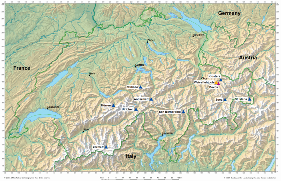
Based on the Swiss Federal Council resolution of 6 June 2008, MeteoSwiss will be lending financial support to the 11 most valuable (longest-running) SWE series from winter 2016/2017. This contribution, coordinated by the Swiss GCOS Office , is providing long-term security for the SWE measurement series. The measuring stations are situated in the altitude zone between 1200 and 2600 m (Table 1) and distributed across a large area of the Swiss Alpine region (Fig. 1). They complement the annual SWE measurements in the Wägital catchment (canton Schwyz) and the winter mass balance measurements that are carried out on selected glaciers in the GLAMOS monitoring network. SLF observers have been performing SWE measurements in the middle and at the end of each month for several decades. They also measure the amount of fresh snow and the overall snow depth every day. The network to which they contribute, which includes those snow stations of special climatological significance (report in German only) identified by MeteoSwiss and the SLF, constitutes a collection of data on the spatial and temporal variability of the snowpack in the Alps that is unique in quality, time span and scope. For several years the operational snow-hydrological service (OSHD) has been using the SWE data to conduct ongoing analyses of the snow water resources and thus improve hydrological forecasting.
Table 1: List of the 11 SLF snow stations where the SWE is measured, which are receiving financial assistance from MeteoSwiss in conjunction with the Swiss GCOS Office. The table also indicates the start date of the fresh snow (HN) and overall snow depth (HS) measurements. |
| Station | Altitude (m) | SWE since | HN since | HS since |
| Klosters | 1200 | 1948 | 1949 | 1948 |
| Ulrichen | 1350 | 1951 | 1942 | 1942 |
| St. Maria | 1420 | 1968 | 1931 | 1951 |
| Andermatt | 1440 | 1947 | 1941 | 1941 |
| Davos | 1560 | 1948 | 1896 | 1893 |
| Zermatt | 1600 | 1947 | 1946 | 1946 |
| San Bernardino | 1640 | 1973 | 1952 | 1952 |
| Mürren | 1650 | 1949 | 1948 | 1948 |
| Zuoz | 1710 | 1951 | 1944 | 1944 |
| Trübsee | 1770 | 1949 | 1940 | 1940 |
| Weissfluhjoch | 2540 | 1937 | 1936 | 1936 |
From a global perspective, the SWE in mountainous regions is a highly significant variable because it regulates the water supply of millions of people living downstream. The long-term data series are enabling scientists to develop their understanding of changes in the available snow water resources over time, and to assess the likely effects of climate change on the water supply. The data can also be used to verify progress made in the ability of the latest satellite technology to observe mountainous terrain. Unfortunately, the inconsistent topography of mountainous regions has thus far severely compromised the reliability of snow resource monitoring performed by modern satellites. For that reason, the SWE data collected in the Swiss Alpine region will serve in future as a valuable aid in validating satellite measurements.
Data will be provided via Envidat.