Obtaining a thorough understanding of the dynamics of snow avalanches is crucial for both the design of defensive structures and the drawing of hazard maps. However, this understanding is limited by the lack of accurate data, since until now there has been no way of accurately tracking the dynamics of large avalanches at high spatial and temporal resolutions. This project, funded by the Swiss National Science Foundation, is to work on a Frequency Modulated Continuous Wave phased array radar called GEODAR(Geophysical Flow Dynamics Using Pulsed Doppler Radar) that images the denser flow features through the powder cloud at a resolution of 0.75m at 100 Hz.
The aim of this project is to study the dynamics of mixed avalanches with the aid of an advanced pulsed Doppler, phased array, radar that provides high resolution imaging of the avalanche dense core. The instrument offers greatly enhanced imaging performance, well beyond that currently available. The research promises to generate new data from which we will gain new insights into the flow dynamics, which will result in well validated, physically based models for hazard and risk applications, such as RAMMS.
The instrument used in this project improves over early remote sensing instruments to study geophysical flows by two orders of magnitude in range resolution as well as having other advantages. The down-slope resolution is approximately 0.75 m compared to 25-50 m for previous instruments. This means that the observations can be directly related to those obtained with other sensors at Vallée de la Sionne (VDLS) avalanche test site, where the radar is actually installed.
The quality of the data from the radar, when used in combination with the other data collected at the VDLS path, such as air pressure, velocity, density, and flow height measurements, has the capability to transform our understanding of a whole class of environmental mass flows such as avalanches and pyroclastic flows that contain similar physics. By being able to follow flow features over the whole track, which are optically obscured, we expect the radar data to be of major importance in validating existing theories and to lead to the development of improved avalanche models.
The project has three main goals. The first is to improve the radar installation, to make it easier to operate, more robust and to implement improved algorithms for the data processing and analysis. The second is to analyze the radar data in conjunction with other data from VDLS to win new knowledge on avalanche dynamics. The third is to test the legitimacy of different constitutive laws for the flows using the data, either in terms of excluding certain constitutive relations as viable candidates, or by constraining parameter values.
Since the first installation in 2010 the radar hardware was constantly improved, e.g. double the sampling frequency and triple the recording time, and the setup especially the phase shifts were calibrated. In 2015 we exchanged the full system to a more advanced system, but unfortunately it suffered from much more electronic noise than the system before. In the season 2016 we set up again the initial system but this time with directional antenna, making the analysis of flow features at different lateral position of the mountain slope much easier.
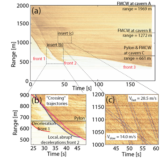
The processing software was improved yielding much better results and especially the MTI plots (Figure 3) were enhanced. The most recent results show small surges in the frontal region of large powder snow avalanches, in the so called intermittent frontal region, which overtake the leading edge one after each other and thus influence the frontal dynamics (Köhler et al, 2016).
The radar was originally constructed by the GEODAR (Geophysical Flow Dynamics Using Pulsed Doppler Radar) consortium funded by the British Natural and Environmental Research council. The current SNSF project is led by Betty Sovilla in collaboration with Prof. Jim McElwaine (Durham University), Prof. Christophe Ancey (EPFL), Prof. Paul Brennan (University College London) and Dr. Chris Keylock (University College London).

Image 1 of 3
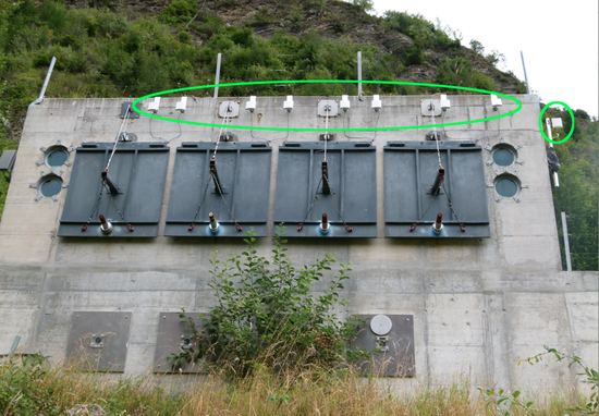
Figure 1: The bunker at Vallée de la Sionne showing the transmit antenna (on the right), as well as the externally (on the top) mounted phased array receive antennas.

Image 2 of 3
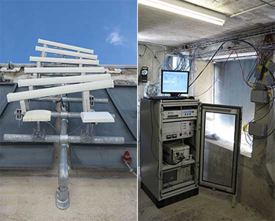
Figure 2: For the winter season 2016-2017 a new system (GEODAR mark IV) has been installed consisting of seven directional antennas, which focus on individual tracks, and one wide angle antenna that covers the entire slope. This will enable more precise measurements of each avalanches lateral location and help in understanding the complex interplay between different fronts and surges. The new antenna array is mounted on the front of the bunker facing the main slope (left) and is connected to the electronics inside the bunder (right).
![Figure 3: Moving Target Indication (MTI) plot for one VDLS avalanche. The signal intensity indicates the change in radar reflectivity as a function of time and distance from the bunker: (a) three individual surges (front 1, front 2, front 3) move downhill over a 3 minute time span, (b) different surges within a front due to the 3D character, the surges may cross or merge in range, (c) roll-waves in the body of the avalanche two different velocities V = 28: 5m/s and V = 14: 0m/s [Vriend et al., 2012].](/fileadmin/_processed_/7/c/csm_highres_radar3_59adc7dac7.png "highres radar3")
Image 3 of 3
Figure 3: Moving Target Indication (MTI) plot for one VDLS avalanche. The signal intensity indicates the change in radar reflectivity as a function of time and distance from the bunker: (a) three individual surges (front 1, front 2, front 3) move downhill over a 3 minute time span, (b) different surges within a front due to the 3D character, the surges may cross or merge in range, (c) roll-waves in the body of the avalanche two different velocities V = 28: 5m/s and V = 14: 0m/s [Vriend et al., 2012].
Contact 
Links 
- AGU highlihts results of this project in their blog "GeoSpace": Avalanches more complex than previously thought
- Large scale avalanche test site "Vallée de la Sionne": Overview and Playlist