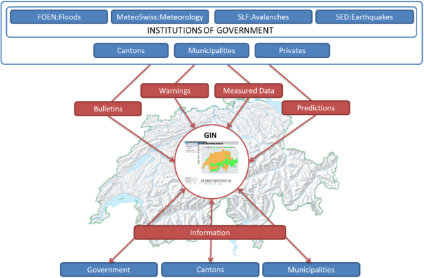
The Swiss Federal Office for the Environment (FOEN), MeteoSwiss, the Swiss Seismological Service (SED) and the SLF are the national agencies responsible for warning other public authorities and the population in case of flooding, severe weather, earthquakes and avalanches. The Common Natural Hazard Information Platform GIN hosts a portal that contains all the relevant information concerning natural hazards.
GIN is a multi-agency product of the FOEN, MeteoSwiss, the SED and the SLF. It is overseen by the GIN secretariat, which is responsible for operating and developing the platform, and for coordinating the collaboration between the individual agencies. The principal users are the natural hazards experts working for the government, cantons and local authorities. The platform itself is for official use only, but the general public are free to use the natural hazards portal.
The time and place of extreme events such as storms, floods and avalanches can never be predicted exactly. In many cases, safety managers at federal, cantonal and municipal levels have to make quick decisions on the basis of a substantial body of diverse information, such as measuring data relating to runoff and water levels and hazard forecasts, to name just a couple of kinds of details. Since early March 2010 this information for specialists has been pooled together and can be viewed on the Swiss federal authorities’ Common Information Platform for Natural Hazardous (GIN).

Content and functionalities
GIN comprises not only forecasts, warnings, models and bulletins, but also current measurement and observation data from the Swiss Federal Office for the Environment (FOEN), the Swiss Federal Office of Meteorology and Climatology (MeteoSwiss), the WSL Institute for Snow and Avalanche Research SLF and the Swiss Seismological Service (SED). Ranging from wind speeds to water levels and on to snow depths, more than 100 measurements from over 700 automated measurement stations are updated in the form of more than 7,000 individual measurements, with for some of them this taking place at three-minute intervals.
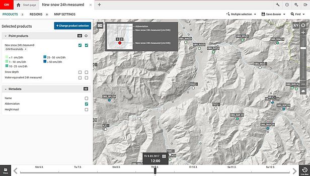
The information and measurement data of the individual specialised bodies can be combined on GIN – something which is particularly useful in the case of floods. The specialists can for instance in the spring show the current runoff along with amounts of snow and the precipitation forecast on a single map. This makes it easier for them to estimate what water levels can be expected in a specific location at a particular time. In this way, GIN helps the taskforces and the authorities to quickly gain a comprehensive picture so that they can assess the level of the hazards and launch measures to protect the public.
Format
On GIN the information is displayed in a uniform way as maps, diagrams, tables, texts or images. The users of GIN can compile data interactively as suits their purposes best. The use of a map format affords a quick overview of the situation at one or more points in time. Diagrams and tables specifically show measurements or observations over the course of time. Another possibility is the indication of moving precipitation radar images in combination with measurement or forecast data.

Outlook
The FOEN, MeteoSwiss and the SLF run a progressive training programme for GIN users and continuously translate practical experience into platform improvements.
How the SLF supports GIN
The SLF supports GIN by providing personnel (for various bodies and in the context of internal activities), financial resources (cofunding of development costs), data and information.
Target audience
Natural hazards experts working for the government, cantons and local authorities.
How to gain access to GIN
Contact the GIN secretariat to confirm whether your organisation is authorised to access the platform. If such authority exists, the GIN secretariat will tell you how to apply for access.
Costs
GIN is free to use for authorised organisations.