Catchment scale snow depth mapping in high-alpine regions using digital photogrammetry
Christian Ginzler
Mauro Marty
Lucie Anne Eberhard

Information on snow depth and its spatial distribution in high-alpine catchments is crucial for many research topics and applications such as avalanche research, hydrology, snow and mountain ecology. Nowadays snow depth values are measured at point locations such as automatic weather stations or from observers in the field and are consequently interpolated to get an estimate of large scale snow depth. Several studies report a high spatial variability of snow depth and other snow pack parameters in mountainous regions, which cannot be reproduced by point measurements. Optical stereo data from different platforms offer a very attractive alternative to derive 3D surface data. Compared to laser scanning, photogrammetry is more economic and with the application of unmanned aerial systems (UAS) also more flexible (Bühler et al. 2016).
Airplane-based surveying sensors 
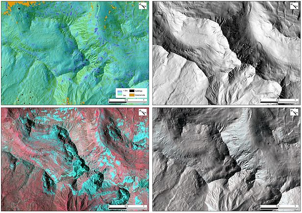
Recent developments of sensor- and software technology for digital photogrammetry enable the generation of high spatial resolution digital surface models (DSMs) from airborne digital imagery even in high alpine regions and over snow-covered surfaces.
For this project, digital imagery from the Leica ADS80 (2010-2013) and ADS100 (2014-2017) opto-electronic scanners for a test site near Davos (145 km2) are used to derive high spatial resolution digital surface models by applying a highly automated workflow. The spatial resolution of the imagery is ~0.25 m (ADS80) and ~0.18 m (ADS100) and the radiometric resolution 12 bit (both). For the dense image matching the spectral bands in the near infrared (), red() and green() part of the electromagnetic spectrum are used.
From winter 2017 we switched to the professional Vexcel frame camera Ultracam X (2017) and then to the Ultracam Eagle M3 (2018 - today). With this state-of-the-art survey camera we were able to improve the ground sampling distance GSD to 0.1 - 0.15 m resulting in higher resolved snow depth maps (0.5 m) as well as higher accuracies.
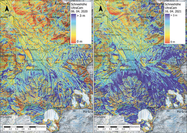
Snow depth maps are calculated as the difference between the winter DSM and a snow-free summer DSM, whereby trees/shrubs, buildings and other infrastructure are masked out. One of the main challenges to derive good quality snow depth maps is the absolute orientation of the ADS stereo imagery, especially in winter due to the limited numbers of usable ground control points in a snow covered landscape.

Products and accuracies 
These results demsonstrate the feasibility of digital photogrammetry to map snow depth and its high spatial variability in alpine catchments. Until now the derived photogrammetric snow depth maps have already been used in different topics in other WSL/SLF groups like the investigation of the dependency of snow depth on elevation (Grünelwald et al. 2014), the parametrization of fractional snow covered area over complex topography (Helbig et al. 2021), the scaling of precipitation input to distributed hydrological models (Vögeli et al. 2016) and in particular for the validation of new, satellite-based snow depth models (Leiterer et al. 2020). The datasets are currently used for various further investigations at WSL/SLF.
Snow depth maps were acquired for the following dates:
| Acquisition date | Sensor | Snow depth accuracy [RMSE] | Spatial map resolution |
| 16.04.2010 | ADS40 | 0.35 m | 2 m |
| 20.03.2012 | ADS80 SH52 | 0.35 m | 2 m |
| 15.04.2013 | ADS80 SH52 | 0.35 m | 2 m |
| 17.04.2014 | ADS80 SH52 | 0.35 m | 2 m |
| 15.04.2015 | ADS100 | 0.30 m | 2 m |
26.01.2016, 09.03.2016, 20.04.2016 | ADS100 | 0.3 m | 2 m |
| 16.03.2017 | Ultracam X | 0.25 m | 0.5 m |
| 11.04.2018 | Ultracam Eagle M3 | 0.15 m | 0.5 m |
| 16.03.2019 | Ultracam Eagle M3 | 0.15 m | 0.5 m |
| 06.04.2020 | Ultracam Eagle M3 | 0.15 m | 0.5 m |
| 16.04.2021 | Ultracam Eagle M3 | 0.15 m | 0.5 m |
| 23. 03. 2022 | Ultracam Eagle M3 | 0.15 m | 0.5 m |
| 22. 03. 2023 | Ultracam Eagle M3 | 0.15 m | 0.5 m |

Collaboration 
Technical Information 
Readme Quality Snowmaps (pdf)