
Remote Sensing 
To an ever increasing extent, remote sensing devices on the ground or mounted on drones, aeroplanes, helicopters or satellites are regarded as key tools in natural hazard research. Thanks to these sensors, data with high resolution covering large areas can be collected quickly after catastrophic events, even in regions that are inaccessible or difficult to reach by land.
The SLF is investigating how such sensor systems can best be used in high alpine regions in the future. Its work is focusing on the following tasks:
- Detailed surveying and mapping of avalanches, debris flows and rockfall events
- Producing up-to-date, precise digital elevation models in high alpine regions
- Recording small-scale snow depth variability
- Large-scale mapping of snow types
- Attributes characterising avalanche protection forests
Detection and mapping of avalanches 
Up-to-date information on triggered avalanches is essential for the avalanche warning services and for avalanche research purposes. Following extreme events, such as those that occurred in the winter of 1999, remote sensing devices can be used to map avalanches over a large area. The primary focal points are the starting zones, runout distances and depths of deposited snow. Enormous quantities of data can be evaluated efficiently and quickly using recently developed techniques for detecting avalanches automatically. The collected information is essential for validating avalanche dynamics models and other purposes.

During the winters 2018 and 2019 the avalanche danger level "very high" (level 5) was predicted for large regions in Switzerland for the first time since 1999. We covered these avalanche periods in collaboration with FOEN and swisstopo with optical stallite data (SPOT6) over large parts of the Swiss Alps (Bühler et al. 2019). Weather independent Radar sensors (TerraSAR-x & Sentinel-1) were also tested (Leinss et al. 2020). Such data analysis proofed to be very helpful for various cantonal authoroties and will play a more important role for avalanche documentation in the future.

Radar sensors can be used to monitor critical slopes, e.g. those above roads and settlements. These offer the advantage of being able to supply data even when visibility is poor (in fog, during snowfall, at night). The researchers are testing ground-based radar sensors on the Dorfberg in Davos and have discovered that even the snowpack acceleration which precedes the actual release of a gliding avalanche can be measured (Caduff et al. 2016).
During the very snow rich winters 2018 and 2019 many avalanche defence structures were filled with snow. To monitor the effectiveness of defence structures, for example wind fences, and to detect potential problems with overfilled structures, we measured the snow depth distribution with drones to acquire information within otherwise inacessible areas (Bühler et al. 2018).

Digital elevation models 
Digital elevation models (DEM) are the point of departure for the numerical simulation of mass movements such as avalanches, debris flows and rockfalls, using RAMMS, and for many other research applications. SLF scientists are investigating various technologies for generating precise elevation models in high alpine regions, including LiDAR and photogrammetric image correlation (see below). At selected test sites with extreme terrain properties they are quantifying the accuracies and identifying systematic errors. They are also exploring the effects of both the elevation model's quality and the resolution on the simulation results (Bühler et al. 2011).
Analysis of avalanche experiments 
At the SLF test site in Vallée de la Sionne (town of Arbaz), large-sized avalanches can be artificially triggered. In order to obtain the greatest possible benefit from these rare events, which are of great value to science, the researchers' tool kit includes remote sensing technology. The snow surface is accurately surveyed via laser scanning before and after the avalanche is released. During the avalanche, the scientists employ photogrammetry to determine the volume of the powder cloud and the frontal velocity. A thermal imaging camera measures the snow temperatures in the avalanche. These data are subsequently used for validating and calibrating the avalanche dynamics model RAMMS.
Small-scale variability of snow depth 
Data on snow depth and its spatial variability are important for numerous applications not only for snow and avalanche research, but also in the field of hydrology. Snow depth information is collected predominantly by means of point measurements recorded at observation stations nowadays, but this method is unable to record the spatial variations which occur in high alpine terrain. SLF researchers are testing remote sensing methods to obtain seamless snow depth data over a large area and thus evaluate the potential of these techniques for operational use. Aircraft-based measurements, when surveying large areas such as the entire Dischma valley in Davos, can achieve an accuracy of 30 cm (Bühler et al. 2015a). Although laser scanning and drones cover only relatively small areas, the measuring accuracy of these techniques is 5 to 10 cm – as compared to the absolute accuracy of manual reference measurements (Bühler et al 2016 & 2017). The recorded detail and high precision broaden the scope of numerous research and practical applications.

Mapping snow types 
Near-infrared solar radiation depends to a large extent on snow properties such as grain size and the liquid water content. For example, old snow composed of large grains and moist snow, in particular, appear much darker than drifted snow composed of small grains. Optical remote sensing instruments can thus be used to differentiate various snow types. The SLF is testing the suitability of drone, aircraft and satellite-mounted instruments for snow type mapping (Bühler et al. 2015b).

Recording attributes of avalanche-protection forests for natural hazard modelling 
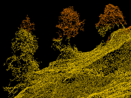
Measured in surface area, forests provide the highest degree of protection against avalanches and rockfall in Switzerland. But what is the best way of measuring and quantifying the effect of protection forests and integrating the relevant data in models? The SLF is exploring the extent to which drones and laser scanning can be used to capture key variables, such as forest density, tree species and dead wood, in avalanche protection forests. The data are fed into and play a part in the simulations performed with RAMMS.
Remote sensing instruments 
There are roughly four types of remote sensing instruments:
optical sensors (passive) measure the reflected sunlight in different wavelengths to acquire information about physical and chemical properties of objects at the earth surface. Such measurements are usually quite easy to interpret and have a high spatial resolution but these sensors cannot penetrate clouds and are therefore not working during bad weather conditions.
thermal sensors (passive) measure the longwave radiation emitted by objects on the earth's surface. This radiated energy depends on the temperature and the material, so that recorded values can be converted into exact object-surface temperatures. The air temperature can be disregarded because thermal radiation permeates air almost entirely. This technology is widely used to detect parts of buildings that suffer large heat losses, but is also very useful in natural hazard research.
radar sensors (active) send out radar waves and measure the signals reflected at the earth surface. Radar waves can penetrate even thick clouds and can therefore acquire data even during bad weather conditions. Radar waves can penetrate material such as snow and provide information on layers below the snow surface. But the radar signals are difficult to interpret and further research is necessary to fully understand the signals.
LiDAR sensors (active) send out waves within the visible and near infrared part of the electromagnetic spectrum and measure the time to the earth surface and back. Using this technology, very precise models of the earth surface can be generated. This methodis usually applied from helicopters and airplanes, recently also from drones. It is mostly suitable for smaller areas.
All of these sensor systems are applied by SLF.
Contact 
Links 
Capturing snow depths by drones
Large scale snow depth mapping
Digital Elevation Models in high alpine terrain
Federal Office for the Environment (FOEN)
National Point of Contact NPOC, Federal Office of Topography swisstopo