MoGLI – modelling woody species in NFI
Rafael Wüest Karpati
Ariel Bergamini
Kurt Bollmann
2017 - 2021
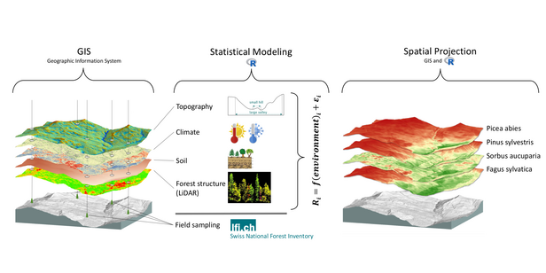
FinancingThe main goal of MoGLI is to project the potential distribution of the most common Swiss woody species across the entire forested area of Switzerland. Good knowledge and spatially explicit information about the potential distribution of species in Swiss forests is important not only for research to, for example, test ecological theory, but also for applied questions related to the use and conservation of natural resources. The MoGLI Project aims to supply this information to researchers and practitioners by producing potential distribution maps of high spatial resolution (25m).
Distribution maps are produced based on the principles of species distribution modeling, where the known occurrence of species (e.g., from the National Forest Inventory sampling) is statistically related to environmental predictors. The potential distribution can then be predicted for the entire forested area of Switzerland using the derived statistical relationship. Apart from traditional predictors such as climate or topography, MoGLI develops new predictors that describe forest structure using LiDAR (light detection and ranging; a method that scans the earth surface using laser-technology), and uses recently developed soil property maps to maximize the accuracy of the spatial projections.

Publications 
Links 
Distribution maps of the most common woody species