Mapping debris-covered glaciers and their features and characteristics
Francesca Pellicciotti
Stellvertretung ProjektmitarbeitendeMichael James McCarthy
Marin Kneib
2014 - 2023
Supraglacial debris greatly alters surface ablation processes and rates, and consequently changes glacier dynamics, geometry, and hypsometry. However, surface debris on glaciers is represented by very few modelling studies in any manner, and is usually constrained to a very small domain. This theme of our research enables the development and application of models to better represent debris by developing the necessary datasets to appropriately represent the complexity of debris-covered ice surfaces.

First, simply determining the extent of ice beneath supragalacial debris and mapping important surface features is a non-trivial task. Rocky debris on a glacier surface appears little different to any other surface of loose rocks of varying size, and is thus often difficult to discriminate based on spectral information (color) alone. Consequently, a major avenue of research has been simply to delineate debris-covered glacier areas in a robust manner, and to assess recent global changes in supraglacial debris. Thus, some of our research has focused on robust assessments of debris-covered ice areas using diverse satellite-based datasets and a variety of approaches.
Second, the debris surface character and properties (debris thickness, conductivity, moisture content, and roughness) are extremely important parameters for the appropriate application of models to predict melt under debris. However, most parameters are only constrained by observations for individual positions or glaciers. Thus, some of our work aims to constrain these parameters from satellite or aerial data.
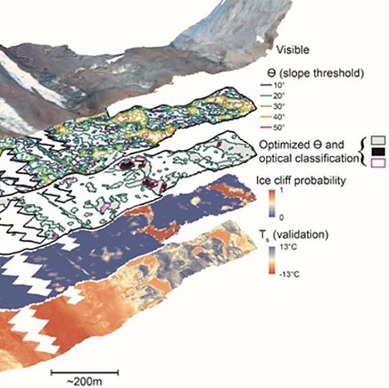
Third, the debris surface is punctuated with distinct features that can lead to considerable, focused ablation: supraglacial ponds and bare ice cliffs. Mapping these features is also not so simple due to their variable states (cliffs may appear as bare ice or wet, thin debris; ponds may be very turbid or nearly clear, or frozen; both can be covered by snow), and because they may be too small to clearly resolve with traditional satellite imagery. Consequently, a priority of our research has been to develop spectral, morphological, and object-oriented approaches to identify these surface features in a robust manner using manual, semi-automated, and automated approaches.
Study area(s)
Global efforts with focused research in High Mountain Asia and Alaska.
Further Project staff
- Sam Herreid (until recently)
- Simone Jola (until recently)
Publications
Herreid, S. and F. Pellicciotti. 2018. Automated detection of ice cliffs within supraglacial debris cover, The Cryosphere, 12, 1811-1829, doi.org/10.5194/tc-12-1811-2018, 2018.
Miles, E., I. Willis, N. Arnold, J. Steiner and F. Pellicciotti. 2017. Spatial, seasonal, and interannual variability of supraglacial ponds in the Langtang Valley of Nepal, 1999 to 2013, Journal of Glaciology, doi.org/10.1017/jog.2016.120.
Miles, E. S., Steiner, J. F., and Brun, F. ( 2017), Highly variable aerodynamic roughness length (z0) for a hummocky debris‐covered glacier, J. Geophys. Res. Atmos., 122, 8447– 8466, doi.org/10.1002/2017JD026510.